Archive for coast

Camino Inglés – the English Route

Traditionally English pilgrims (when England was still Catholic) or other northern European pilgrims (ditto) sailed to the ports of El Ferrol or La Coruña and journeyed south from those points on what we now call the Camino Inglés (English Route). It’s a north-south route straight into Santiago without coinciding with the French route.

Nowadays the Camino Inglés is a lot less travelled than the other historical routes like the French, Portuguese or coastal routes. If you’ve done other Camino routes, or have not (yet) but want a shorter or less travelled option the Camino Inglés is a good choice.

Guidebook: John Brierley’s book on Sarria – Santiago – Finisterre, including the Muxia circuit and the Camino Inglés.

When walked: July 7-11, 2017

Route: Ferrol – Santiago, about 123 kilometers. Another branch starts in La Coruña, about 76 kilometers so does not qualify for the Compostela certificate (if that is important for you), though La Coruña is a nicer city than Ferrol.

What’s good and less good: I really liked the mixture of sea and mountains first three days, then the transition to countryside. Lots of varied forests, including chestnut trees at a low altitude. Less good: walking Ferrol – Fene (about 20 kilometers) has a fair amount of industry (old shipyards) and warehouses. Part of that is unavoidable but I can’t help wondering if they could have routed around instead of through some of the warehouse areas.

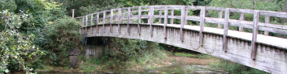
Usual stages and other ideas: Brierley’s suggested six stages are probably the best for distances and infrastucture: Ferrol – Neda (15.5k), Neda – Pontedeume (16k), Pontedeume – Betanzos (20.7k), Betanzos – Hospital de Bruma 28.4k, big hill), Hospital de Bruma – Sigüeiro (25.2k), Sigüeiro – Santiago (17.2k), all distances as per Brierley. I did it in five stages (Ferrol – Pontedeume first day), and it’s also possible to break Betanzos – Hospital just short of the halfway point.

Important note: route changes in near future: if you are planning to do this route soon: some routing changes are planned and will be marked this fall, so be aware that current guidebooks will not be 100% accurate. New route will hit all the major towns and many of the smaller ones; in some places changes will be minor and in other places more important (one local woman says the new route from their town into Sigüeiro is much better than current route). At least one change has already been made: shortly before Hospital de Bruma (well after Casa Julia): the official signage seems to disappear, replaced by handmade yellow arrows nailed to trees and newly painted arrows with slightly different color of yellow. Fear not, the apparent improvisation is the real route (for now) and re-connects with official signage.

Signage: Better than expected but not perfect. There are lots of crossroads and you have to watch carefully, sometimes signage is there but not immediately visible from your angle or covered by vegetation. Lots of arrows painted on the asphalt.  Going through industrial / warehouse areas can be tricky, especially just outside Santiago, where there is almost no signage (basic idea for Santiago warehouse area: after turning left into warehouse area stay straight ahead through two rotundas, walking on left side of the road, warehouses are on the right side of the road. Signage reappears shortly after last warehouses).

Infrastructure: Fewer supermarkets, albergues, pensiones, hotels, bars than on the Camino Francés, Camino Norte or Camino to Finisterre. Not a deal-breaker, but you do need to be more aware of your supply places.

Places to sleep: Most of these places are listed in Brierley book. Ferrol: I stayed at Hostal La Frontera, good location but a little minimalist and bar doesn’t open until 8am. Nearby Hostal Zahara (not in Brierley) looks nicer and bar opens at 6am for breakfast (excellent tomato toast). Camino friends recommended La Almendra. Pontedeume: I stayed at Hostal Norte and wouldn’t repeat, no elevator, very minimalist, bar opens at 8.30am. Nicest hotel Eumesa is at a very busy intersection, Pension Luis is well located but looks very small. My pick here would for a repeat visit probably be Hostal Allegue. Betanzos: I had a reservation at Posada Cheiño, but switched to Hospedaje Betanzos, where a little more money got me a huge room with bathroom (other place didn’t have bathroom) and access to a full kitchen. Camino friends say the municipal albergue here is excellent. Hospital de Bruma: I stayed two kilometers up the hill at Hotel Canaima (Alto do Viento), nice room with full bathtub to soak your weary body after long day and big uphill – though neither dinner nor breakfast at the hotel was memorable, and price was a little high. Almost right across the highway from the hotel: Pension o Meson Novo, less expensive though no idea on what it’s like (you do not have to return to the albergue to continue the Camino, there’s a paved road that does a diagonal to join the Camino several kilometers beyond the albergue). Same Camino friend who recommended Betanzos albergue says the Hospital de Bruma albergue is very good, but there are only 22 spaces so the hotel / pension are good to know about. Sigüeiro: Stayed at Sigüeiro hostal and really liked it, this was my favorite accommodation on this trip. New with modern design, nice bed and interesting bathroom setup (shower and toilet in one space, sink outside in the room, much more efficient for sharing a room), very good dinner and good breakfast.

Places to eat / have coffee: Surprisingly, I did not see any “menu del día” deals. This fixed price menu idea is all over Spain, not just on the Camino, and not seeing any at all was strange. That has price implications, since the fixed price menu is usually a much better deal than ordering off the menu, so you will need to pick and choose both your places and what you eat. Places to stop on the trail: The Brierley book is pretty accurate though not 100%, due to scarcity of stopping places it’s good to plan ahead to be sure you have water and food. Places I stopped showing my stage breakdown, either memorable or not in Brierley or not well described in Brierley, other bars exist most days: Day 1: Neda-Santa Maria, no bar at Neda pedestrian bridge by the albergue, continue another 15 minutes to find a bar just beyond Santa Maria church (not in Brierley), Vilar de Colo bar is in the warehouse area, not in the town. Day 2: Miño: bar Green (memorable), turn right down short flight of stairs when you see the basketball court-square, bar is under arcades on left side of the square. He gave me a chunk of homemade poundcake (bizcocho) and slices of melon and watermelon for free, plus some tourism pamphlets (supermarket in same square). Day 3 ( Killer Day Betanzos – Hospital de Bruma): Only two bars on a long and challenging day, first in Presedo,  Xente do Camiño (memorable) which is well after the sign for the local albergue, good place with food and big outdoor sitting area and second in Vilacoba, Casa Julia which is small place right on the highway, easy to walk past but a stop is highly recommended since (for now) this is last stop before Hospital de Bruma. Casa Julia is also the place they count pilgrims, see below, if you speak Spanish chat with the young man. He was making filloas (local version of crepes) when I went by on a Sunday, handing them out to all customers. Day 4: Centro/Calle, bar Cruceiro, friendly with good potato omelette, empanada and poundcake, a classic Camino stop. Day 5: Hotel Castro (not in Brierley), about 2-2.5 hours from Sigüeiro. Places in towns (mostly dinners), I ate at these places: Ferrol: bar-restaurant near main square, right in front of Pescaderia fish market, excellent seafood, big outdoor sitting area. Pontedeume and Betanzos both dinner spots were forgettable, both towns have a lot of options. Breakfasts in those towns: Pontedeume, Café Martinho is right in front of the bridge, opens 6am. Betanzos, Churreria-cafeteria just to the left of calle Rollo (Camino street), near though not on calle Venezuela, opens 6.30am except Sundays when 7am or in fiestas when 8am. Hospital de Bruma, there’s a restaurant right by the albergue that my Camino friend likes, I didn’t stop since I was going on to the hotel, where dinner was forgettable. Sigüeiro: cruised town and did not find many options, perhaps because of Monday closings, ended back and Sigüeiro hostel and had a yummy dinner of mushrooms and potatoes, good food at a good price AND they have a secret back terrace that you do not see from the front, very good choice for dinner.

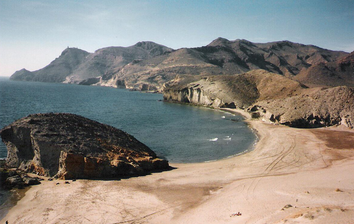
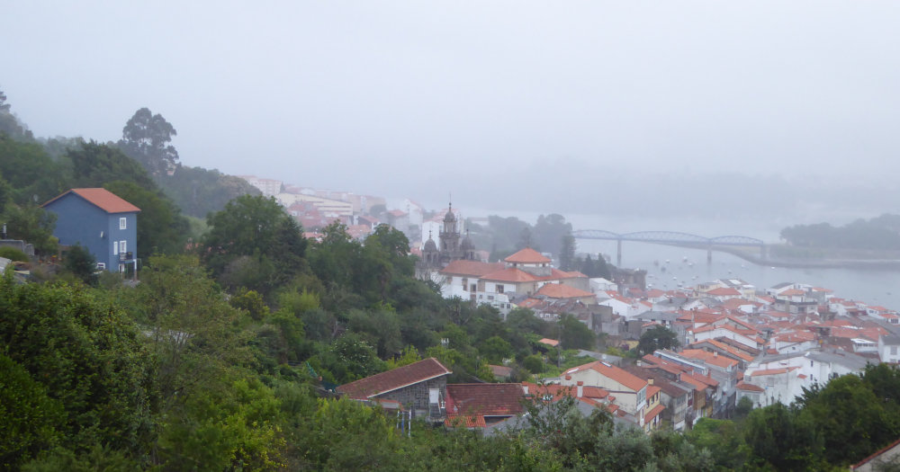
Beaches: Weather was not cooperating during my walk so I didn’t even dabble my toes in the sea but here are my observations: several beaches on the way out of Ferrol, excellent La Magdalena beach in Cabanas just before Pontedeume, and just after Miño near Ponte do Porco.

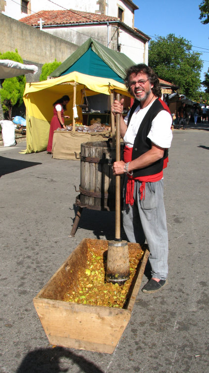
Fiesta Betanzos: My trip coincided with the Medieval Market in the medieval town of Betanzos. Market was cute and had nice things – but backpacking you have to think at least twice before buying anything. If you are planning for the future and want to see this or avoid it (town was packed to the rafters), check the dates: it’s probably the second weekend in July.

People on the trail: This route is a lot less travelled than other routes – my “bubble” (people more or less in same space on same day) was about 25-30 people. The young man in Casa Julia (see above) says he counts pilgrims and that day (a Sunday) he had seen 21 so far – he counted 2000 pilgrims last August (about that many daily arrive in Santiago early July). Obviously 25 people a day is not a lot – but several albergues are about that size so good to plan accordingly and know your options.

Going alone? I saw two other women walking alone, and two other Italian women who were sort of together and sort of not together. I felt completely safe, but it must be said that women alone are still a little unusual here so if you are a woman and go alone you might get some comments (like I did). For that reason, if you have never walked alone and are feeling a little uneasy about it, perhaps a more-travelled route would be better for a first solo experience.

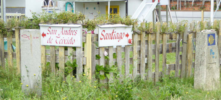
Want more walking? Before your Camino Inglés: San Andres de Teixido is about 50 kilometers from Ferrol, according to the Ferrol tourism office marked all the way with stone pillars with a red fish (see photo). Actually, if you want to put together a longer route, part Camino de Santiago and part local custom, start here: https://caminoasanandres.com/ (Spanish only, sorry), scroll down a tiny bit and click on Caminos de San Andrés: if you know your Camino de Santiago routes you’ll see Ribadeo (north route) and Ourense (Via de la Plata / Sanabres route), as well as other towns on the Camino Ingles as starting places to walk to San Andres, so you could put together a longer combo route in this area. Galician lore says that if you don’t visit San Andrés while living, you must visit after death, so locals often make pilgrimage to this site, more important for them than going to Santiago. Learn more about the San Andrés route: https://en.wikipedia.org/wiki/San_Andr%C3%A9s_de_Teixido     After your Camino Inglés: what better choice than Santiago – Finisterre – Muxia? The journey to Muxia for Virgen de la Barca / Virgin of the Boat is again more important for locals than Santiago – celebration date is the first Sunday after September 8. For more about this shrine go to http://concellomuxia.com/en/item/santuario-da-virxe-da-barca/

Cabo de Gata: Sea and Sun – and lots more


Like sun? Like nature? Like outdoor sports? Like lesser-known destinations, and don’t mind a longer drive or figuring out some transportation options?


Then consider Cabo de Gata, the southeast tip of Spain. Almost desert-dry, with the lowest rainfall in all of Europe, so your chances of warm, dry weather are pretty good most of the year, and there are things to do if the sun doesn’t shine during your entire stay.

So exactly where is this? Between Mojácar (south-ish on Spain’s east coast), and Almeria city (east-ish on Spain’s south coast), and everything east of a line through Níjar connecting the two places – plus a bit north of that line (Sorbas and Tabernas).

Cabo de Gata Natural Park: One of the main attractions of this area is the Cabo de Gata Natural park, declared in 1987. Thanks partly to park zoning, the coast between Mojácar and Almería has mostly escaped excessive development; farther back in time the lack of water also hindered development, so now you can enjoy a relatively pristine coast. “Relatively” pristine, as ironically, the park did bring some rather unfortunate building in urban areas, along with much needed money from increased tourism. Hopefully the park zoning and environmentalist interest will help guide the area’s development in the future.

So what’s to see?

Along the coast

— Villages or man-made: Mojácar, charming white village on a hill overlooking the sea. Agua Amarga (south of Mojácar) and Cabo de Gata (south coast, east of Almeria), two old fishing villages, now developed but still with a bit of old flavor. Cabo de Gata lighthouse on southeasternmost tip, placement and view. Cabo de Gata saltpans, probably used in Roman times and still in operation; saltpans are between lighthouse and village. Almeria city, castle and Cathedral built on site of a 10th century mosque; can see bits of mosque but not as spectacular as Córdoba. Almeria city also has a museum with some archeological artifacts from the area, though the best pieces are in Madrid.

— Nature: View from Mesa Roldan lookout. Rock formations, all along eastern coast but especially between San José and the lighthouse, in the sea and on the beaches. Crater of old volcano, northwest of Los Escullos. Flamingos and other bird life in salt pans near Cabo de Gata village. Sand dunes, especially Playa de los Genoveses. Best beaches: Monsul and Genoveses beaches near San Jose. Agua Amarga beach, small but nice, and beaches south of that village, some only accessible on foot at low tide. El Playazo, near Rodalquilar village. Cabo de Gata village beach is long but rather rocky. Some nice beaches near Carboneras (east coast) but nearby cement factory is a bit off-putting. Mojácar’s beaches are smallish and outside town. San Pedro nudist beach just north of Las Negras (nice walking path to get there, 40 minutes); this used to be a lovely, almost pristine beach but has some issues now –illegal bars, “alternative lifestyle” settlement that is not terribly respectful of the environment.

Inland

— Villages or man-made: Near Tabernes: several US – Western town film sets remaining from the 1950-1970’s era of “paella westerns”, host to stars like Clint Eastwood, Brigitte Bardot, Harrison Ford, Raquel Welch and others. Nijar village, one of largest in the area and typical of inland Almeria. “Norias” or water-wheels to draw water for irrigation from underground, one of the best is in Pozo de los Frailes. Abandoned gold mines near Rodalquilar. Cortijo del Fraile ruins near Rodalquilar, site of the events described in Federico Garcia Lorca’s tragedy Bodas de Sangre (Blood Wedding). Archaeological sites (prehistoric and Roman), interesting for history buffs.

— Nature: Tabernas desert, limestone “karst” formations around Sorbas: at least Aguas and Covadura caves, also some gorges so narrow they look like caves.

Environment / sports: There are lots of opportunities for activities in nature (diving, kayaking, hiking, cycling, horseback riding, caving in Sorbas) BUT please remember this is a natural park in a fragile environment, with permit requirements or restrictions for some activities. As always, leave no litter, and if you see any left by less considerate visitors, perhaps you could do a good deed and pick it up. Information on active travel companies in links below.

Shopping: Traditional crafts include ceramics (often cream and blue, some greens and grays). Rag rugs called “jarapas”: these rugs were often used on beds to protect the bedspread. Woven grass mats and baskets. “Indalo” fertility goddess symbol, a stylized stick figure with outspread arms. Good places for shopping: Níjar, Sorbas, Mojácar, San José.

When to go: October – May, with early June and late September a possibility though with higher temperatures. I have swum in the ocean in December (and don’t consider myself especially fond of cold water). BUT….. If it rains, it (usually) pours: Yes, this is the driest part of Europe, but when it rains, it is often a downpour that can cause flash floods. Notice the number of no-bridge stream crossings, where minor paved or unpaved roads dip down over a gully. Heavy rains can and do fill these empty gullies with roaring rivers (hard to believe but true). If that happens, do not try to drive across what was yesterday a dry gully. Ask locals about alternative routes, or even better, ask local police or Guardia Civil; they’ll be in charge of any rescue operations so give them a chance to stop the rescue situation before it happens.

Best villages to stay: Mojacar, Agua Amarga, Las Negras, Rodalquilar (a little inland), San Jose, Cabo de Gata all have hotels of different styles and prices.

How to get there: By car: Fastest but less scenic: southeast to Murcia, then south through Lorca; this is the best route if you plan to stay in Mojácar or Agua Amarga. Most scenic, more challenging driving: to Granada then south through Sierra Nevada and southeast to Almeria through the Alpujarra mountains on smaller roads (several possible routes). Other transportation: Almería station is centralized for train and bus. Madrid – Almeria is a very long trip, so direct bus not a good idea, but Alsa buses run from Jaen, Granada, Sevilla and Malaga. Renfe has direct Madrid – Almeria train service, usually one or two trains a day, sometimes more April-September (www.renfe.es); alas, the convenient night train seems to have disappeared. Almeria does have an airport, and flights may be cheaper than the train. Many towns in this area are connected to Almeria by bus, so if you don’t plan to move around much, public transportation is possible.

And last but definitely not least, that question you may be asking yourself: Why is this called Cape Girl-kitty? And the answer is: the name doesn’t come from “cat” but from “agate” (semi-precious stone) that used to be found along the coast. And yes, if you know your rocks and you’re really lucky, you still might find an agate or two.
Websites for more information / pre-trip planning: English version not always available or complete.

https://www.cabogataalmeria.com/ Good general site with lots of links, well organized. This would be my first pick. On this site, info on the “Western” towns: http://www.cabogataspain.com/Gata-Nature-Reserve/Activities/Leisure/Western-Village-Tabernas.html

Other sites:
www.cabodegata-nijar.es
www.degata.com

Inicio

http://www.museosdeandalucia.es/cultura/museos/MAL/      Website for Almeria Archaeological museum.

https://www.turismodealmeria.org/prepara-tu-viaje/como-llegar/    Some info on bus lines in the province of Almeria.

More information, once you’re there:
Park visitor’s center: Centro de Interpretación de la Naturaleza Las Amoladeras,
Highway AL-3115, Tramo Retamar-Pujaire Km. 7.

Other places for additional information (park or general tourism), take your pick here: https://www.cabogataalmeria.com/Cabo-Gata/Parque-Natural/Puntos-Informacion.html


Cider in Spain

201612ciderapples


What traditional Spanish beverage needs a good eye and steady hands to be at its best? What traditional Spanish beverage is almost a sign of identity for its region? And what traditional beverage has a long list of health benefits?

The answer to all three questions is: sidra: hard apple cider, popular in many European countries and to some extent on the other side of the Atlantic. Here in Spain it takes on a personality all its own, with legends and lore galore.

Spain’s cider-land is mostly along the north coast: Basque region, Cantabria and especially Asturias, where about 80% of Spain’s cider is produced – and drunk, with about 90% consumed right in the region. For that reason we’ll talk about Asturias in this article – though by all means you should try sidra when traveling in other cider regions.

So what is sidra like? It’s a lightly alcoholic beverage made of fermented apple juice – in Spain usually 4º – 6º (like a hearty beer); alcohol content is sometimes higher in other countries, where the espumoso (bubbly) cider is more frequent than the natural that is so popular in northern Spain.

Cider apples are usually not table apples – they’re a little smaller and juicier. The Regulation Council for Asturian Cider accepts 22 varieties of local apples, rated as tart, sweet, bitter or mixed.

Like wine, cider makers use different mixtures of apples to get the final product they want. That’s quite an art: like grapes, apples are different every year, with varying sugar content depending on the weather, so finding the right mixture of still unfermented juices is a delicate process.

Depending on the manufacturing process and apples used, sidra can be very pale yellow to dark gold in color, and clear or slightly cloudy. Some ciders are bubbly and some are not – see the end to learn about different kinds of cider.

201612ciderpressMaking sidra natural The process is simple – many tiny cider houses and even country families and make their own for family and friends: see photo of Guillermo showing the traditional crushing – he’s made his own and explained the process, which is not very different for the industrial process.

Apples are harvested between September and late November, depending on the year’s weather and the variety of apples. Apple trees yield differently alternating years, with the even-numbered years a smaller harvest and the odd-numbered years cosechonas (big harvests), when the much larger harvest can last until early December.

First the apples are washed, then crushed to pulp separately by apple variety. The next step is pressing – the apple pulp is layered in a press that works with weight or a screw system and pressed several times to get all the juice. What comes out is apple juice, ready for the fermentation process (the almost dry apple pulp is often fed to livestock).

The juice is placed in stainless steel or chestnut wood vats to ferment for three to five months – shorter aging for a sweeter cider or longer for tarter cider, always varying with the kind of apple used. Cool weather is good for fermenting, so the temperature is controlled carefully during this time. After fermentation comes bottling in the traditional green bottles, taking care to not stir up the cider too much.

At bottling time, traditional llagares (cider houses) often still have a cask-tapping party called espicha for the holes in the cask. The espicha had – and still may have – the practical purpose of finishing off the unbottled cider in a cask or as a taste-test before buying a whole cask, but more than anything it’s a big party, with cider is drawn directly from the cask into pitchers or e traditional big glasses. Long ago, revellers would pay a flat fee into the cider house to drink all they could – and would pay again when returning after a potty break.

Sidra is as Spanish as vino  (wine) – and maybe more so in the north. So be sure to try it during your time in Spain – preferably up north, or at least in a Madrid cider bar.

Basic kinds of Asturian cider

Sidra natural is the traditional, most popular kind of cider, rather tart, even somewhat bitter if not poured correctly. Variations on this kind of cider: Natural ecológica, made with apples from orchards with ecological certification; Natural de manzana seleccionada, made with specific varieties of apples that have undergone an even more rigourous selection process.

El escanciado (pouring): Sidra natural should be poured from a bottle held arm’s height above the head into a big glass held at a slant at thigh level. That aerates the natural cider, making it a little sweeter and raising some bubbles – and that’s when true cider buffs can evaluate the cider for color and aroma. The sidra should be poured in a thin stream directly in front of the body, just hit the edge of the glass – and just enough for a few swallows as the bubbles soon disappear. After drinking, the last swig is poured on the floor to rinse the edge of the communal glass.

That’s the technique – but good escanciado is more than just technique. Style and ritual matter: a good pourer is admired for the ability to pour without looking and without splashing too much on the floor. The way the bottle and glass are held, even the flourish used to present the glass to the drinker, all are important parts of the escanciado ritual. The communal glass itself is part of the cider lore: sharing a glass puts everyone on the same level and last – but not least – lore says that pouring the last bit onto the floor thanks the earth for the cider, returning to the earth a bit of what the earth has given.

Obviously, drinking sidra natural the traditional way is a messy business. Inevitably some splashes during the escanciado, and pouring that last bit on the floor – well, cider bars always have sticky floors. Some cider bars now use the traditional glass and mechanical pourers, less fun but less messy, and smaller bars may use a plastic spout that does an ok job even with a regular glass, though without the charm of the traditional escanciado.

Sidra espumosa is a less-messy kind of cider. Like sidra natural, it’s made from fermented apple juice – then undergoes an additional process to create natural bubbles. This cider should not be confused with sidra achampañada, usually made with apple juice concentrate and added gas – the label should tell you what kind is in the bottle. Both kinds are bubbly, and often drunk at Christmas as a “poor man’s champagne” – but don’t wait for Christmas to share a bottle with friends – the bubbly goes really well with cheesy popcorn and a good movie.

Sidra natural nueva expressión A new product – it’s like sidra natural, but needs no special pouring. The manufacturing is slightly different, including a filtering and stabilization process. Supposedly this cider is fairly dry, with a hint of natural bubbles. It’s marketed as a lighter wine or “restaurant cider”. Hard to find in Madrid.

Coming in the future: ice cider (already made in Canada), brut cider (like cava), light cider, good quality cider vinegar and a lot more!

Cider trivia
– Apple varieties in Asturias: 2500 DIFFERENT kinds of apples!
– Cider manufacturered in 2015: more than 2.8 million liters (almost a million liters more than previous high-yield year 2013)
– Apples to cider, yield: it takes a little more than a kilo of apples to make a liter of cider
– Measurements big glass for sidra natural : 12 cms high, 9 cms wide at the mouth and 7 cms wide at the base (about 5 X 3.5 X 3 inches).


Ribadesella

Ribadesella seaside promenade from Virgen del Guia chapel


Ribadesella lies on Spain’s green northern coast in the region of Asturias, about 70 kilometers / 44 miles east of Gijón. As the name tells us, it’s on the bank of the Sella river; actually, it’s on both banks, connected by a long bridge over the Sella estuary. A quick look at a good map shows us that the coastal plain is quite narrow and backed by mountains, first a lower coastal range then the majestic Picos de Europa. That location makes Ribadesella a great destination for exploring eastern Asturias, both the coastal plain and part of the mountains, with many options for cultural and active travel.

Flashes of history: Local cave Tito Bustillo shows population from prehistoric times, though the first written record of the town is from the Greek historian Strabo in the first century BC and the official town charter is thirteenth century under King Alfonso X. In the seventeenth century there was a project to make Ribadesella the main port in Asturias by connecting the town to inland Castilla region, but in the end that honor went to Gijón (main pass into Asturias is Pajares, accessing Oviedo then Gijón). In the early nineteenth century this strategic town was occupied by Napoleon’s troops during the Peninsular wars. Early in the twentieth century the town was a favorite summer residence, as shown by the mansions remaining along the beach; King Alfonso XIII visited here though usually stayed at Santander to the east. At the beginning of the Civil War (1936) Republic forces held the town to try to stop Franco’s army westward march after taking Bilbao and Santander; in their retreat west the Republic soldiers blew up the bridge to slow Franco’s forces.

Originally the economy was based on timber coming down the Sella river, shipyards, maritime trade, fishing and whaling. Nowadays it’s mostly tourism with some farming, livestock (cows for cheese!) and a bit of fishing.

What to see, in town:
Long, lovely beach on west side of the Sella river. Architecture promenade with mansions from the early 20th century along the beach, explanations of the most notable buildings (two now hotels, one the youth hostel).

Tito Bustillo cave with cave paintings, one of several prehistoric caves along this coast (Altamira to the east is the most famous). The cave is very interesting, though English speaking guides not always available and cave closed November – March as well as part of the week rest of the year to preserve the paintings. If visiting the cave is too problematic, the attached visitors’ center is excellent (information English as well as Spanish), so good that doing both is worthwhile for people who like history. More info at their website www.centrodearterupestredetitobustillo.com

Virgen del Guia chapel, on the bluff on the east side of estuary where it meets the sea, visible from most of the town. This chapel was founded in the sixteenth century at a strategic place for controlling the entrance to the estuary and port; the cannons were thrown into the sea by the French in their retreat, returned to their original site in 1999. It’s a bit of a climb to reach the chapel, but the views of town and to the east are very good. The easiest way up: from the east end of the seaside promenade, just under the chapel, where a marked path zigzags up the bluff. Way down: once up there it’s easy to see other alternatives for walking back down.

International Sella descent, from Arriondas to Ribadesella, a big yearly event in early August. With professional kayakers and canoers at the front, inner tubes and other recreational floats at the back, it’s a big party as well as an elite sports event. Spectators can take the narrow gauge train that runs on the riverside spur only for race day.  More info www.descensodelsella.com/index.php/es/

La Cuevona cave, not exactly in town but so close it is included here. This huge cave is a little south of Ribadesella, on the west side of the Sella river. It’s so big that it was refuge for eight villages during the Civil War (1936-39). The paved road through the cave is the only access to town Cuevas del Mar.

Sella estuary looking inland

Sella estuary looking inland

What to see, nearby:

Asturias Jurassic Museum has lots of information the dinosaurs that roamed this area. Where: a little west near Colunga, website www.museojurasicoasturias.com/ More dinos: Many beaches along this coast have dinosaur tracks. Cute towns: Llanes to the east, Lastres and Tazones to the west. Many good beaches between Unquera in the east and Gijon in the west. Oviedo (Asturias capital city) to the west has several outstanding pre-Romanesque churches; other similar churches are nearby.

Active travel, walking: Ribadesella is on the northern Road of St. James. Since that route is linear, take bus or train one way and walk the other. Strong walkers could take the Road west to Vega beach (near Berbes) and return to town along headlands through village of Leces. There are several circular walks from town, though not all well marked. More info on those routes on the town website and at the tourism office.

Active travel, other: Several local travel companies can organize kayaking on the Sella river, usually the descent from Arriondas with option to shorten partway through (most of the year that’s an easy paddle even for beginners). Some of those travel companies can also help with routes in the Picos de Europa, most notably the classic Cares gorge, a spectacular linear route where organized drop-off and pickup makes this day hike much easier to manage. Bike rental and even surfing classes also available locally; golf course a little west in Berbes.

Gastronomy: Lots of restaurants with good seafood, too many to mention here. Many are along the seaside promenade (especially east side of the Sella), and with that variety you can pick and choose – they tend to be a little less expensive farther out. If you’re in town fall to spring, try the fabada bean stew: with sausage and other yummy things this is a hearty meal not usually available in the summer, and not recommended for dinner. Asturias region has a huge variety of cheese, from sinus-clearingly strong Cabrales (blue-ish) to very mild and gooey or crumbly, with everything in between. Drink of choice in Asturias region: hard cider, somewhat of an acquired taste though the obligatory pour from arm’s height into a big glass is fun to see and almost a ritual in the region. Chocolate shop with a big variety of things made of, well, chocolate. Just looking in the window is a treat, fun place to get gifts. Ok, maybe it’s Ghirardelli, but part of the fun is finding a place like this in a seaside town in Spain. www.chocolosophy.es/

Nuts and bolts for Ribadesella:

More information: For pre-trip planning, town website www.ribadesella.es/ Part (not all) of the site is in English. In town: tourism office near east end of the big bridge. Good map for entire region of Asturias: Michelin Zoom España number 142.

How to get there, public transportation: Ribadesella has frequent buses west to Oviedo and Gijon, and some buses east to Santander. More info (English) on Alsa website www.alsa.es/en/ The narrow-gauge coastal train between Santander and Oviedo is somewhat less convenient due to schedules and station location, but the train route is prettier than the highway and the train is more fun (especially with kids). More information on FEVE section of Renfe website: www.renfe.com/viajeros/feve/horarios.html